A University of Washington researcher is hunting for answers about last year’s landslides in Old Clinton, and he’s looking for the community’s help.
Justin Brooks, a graduate student with the university’s Earth and Space Sciences, applied geoscience masters program, is studying the series of slides that destroyed or damaged several cabins on Campers Row Walk in 2014 and 2015. He’s got a hunch that the events’ triggers were more complex than the old “lots of rain” explanation, and that understanding the circumstances better will not only further scientists’ knowledge about how and why landslides occur, but may also help predict future movements.
“Landslides affect all the bluff areas throughout Puget Sound,” Brooks said. “It would be nice to come up with some kind of warning so there are no fatalities.”
His work is specific to Brighton Beach and the geology there, but Brooks’ findings could provide a framework for research in other landslide-prone areas throughout the region, according to Terry Swanson, a Whidbey geologist and principal lecturer at the University of Washington.
“It could serve as a template,” he said.
Swanson specializes in slope stability and is providing oversight of Brooks’ research.
The slides at Campers Row Walk, a walk-in shoreline community between Hastings and South Brighton Beach roads, occurred over a roughly two-month period. The first significant event happened in late December 2015, destroying one cabin and damaging another. Additional slides in February and March 2015 razed a boathouse and another cabin to the south. Finally, a fifth cabin was lost to a slide in the same area more than 20 years ago. The lot has remained vacant ever since.
The ultimate goal of the research is find out why the landslides occurred. To do so, Brooks said he’ll examine substrate geology, precipitation thresholds, development within the recharge area and other potential triggers. One of the big focuses is, of course, rain.

It’s no secret that landslides are often connected with heavy rainfall, but what’s less understood, according to Brooks and Swanson, is the amount and frequency of precipitation required to trigger an actual event. For example, late 2014 and early 2015 was a particularly wet winter but not the wettest.
“We’ve had much bigger precipitation events, so why now?” Swanson said.
The Brighton Beach landslides may have been subjected to a series of heavy rainfalls that occurred over a relatively short period of time, weeks or a month, rather than an entire season or even years. A bombardment may not have given the geology of the bluff — largely layers of sand and clay — the time it needed to drain. Boiled down, water trapped in the clay layer below the surface may have become overloaded, causing everything above it to collapse.
Determining how long the area needs to drain, or the time required between heavy rainfalls, could be the “smoking gun” for Brooks, Swanson said. And a trend may be just what’s needed to warn remaining beach residents that another slide is imminent.
“If they [conditions] follow a similar pattern, we can tell folks that if we have a [certain] sequence of events they should keep their eyes open,” Brooks said.
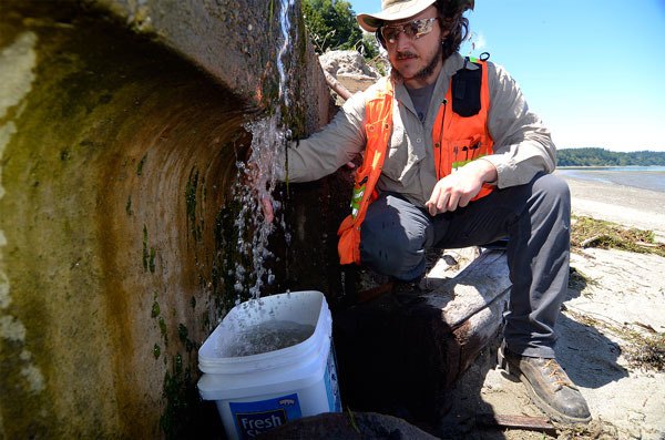
To determine if the hunch is correct, Brooks is measuring water that’s still pouring off the bluff. The stream drains over a bulkhead at the beach. The measuring procedure is simple, consisting only of a bucket and a stop watch.
“We’ve averaging about four gallons a minute,” Brook said.
He began in April and plans to continue into October, but he’s looking for a few extra hands. Brooks is hoping beach residents will step forward and help take measurements at least twice a day, but he’s also looking for any data about past events at Brighton Beach; locations, dates, times, the more specific the better. Precipitation logs or borehole/well log data would also be useful.
To participate, email Brooks at kiyote@uw.edu or call or text him at 813-205-3481.


